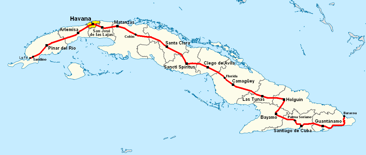
Datei:Carretera Central map (Cuba).png
Größe dieser Vorschau: 800 × 339 Pixel. Weitere Auflösungen: 320 × 136 Pixel | 640 × 271 Pixel | 1.200 × 509 Pixel
Originaldatei (1.200 × 509 Pixel, Dateigröße: 107 KB, MIME-Typ: image/png)
![]()
Diese Datei und die Informationen unter dem roten Trennstrich werden aus dem zentralen Medienarchiv Wikimedia Commons eingebunden.
![]()
Beschreibung
| Beschreibung | Note: A file on EcuRed was updated on 15 February 2013 to a new version, based on this file, updated on 31 January 2013. |
| Datum | 28. Juni 2006 (Original-Hochladedatum) |
| Quelle | Die Autorenschaft wurde nicht in einer maschinell lesbaren Form angegeben. Es wird angenommen, dass es sich um ein eigenes Werk handelt (basierend auf den Rechteinhaber-Angaben). |
| Urheber | Die Autorenschaft wurde nicht in einer maschinell lesbaren Form angegeben. Es wird Qyd als Autor angenommen (basierend auf den Rechteinhaber-Angaben). |
| Andere Versionen |
|
.png)
.png)
.png)
.png)
.png)
.png&action=edit&redlink=1)
.png?uselang=de)
Lizenz
| Ich, der Urheberrechtsinhaber dieses Werkes, veröffentliche es als gemeinfrei. Dies gilt weltweit. In manchen Staaten könnte dies rechtlich nicht möglich sein. Sofern dies der Fall ist: Ich gewähre jedem das bedingungslose Recht, dieses Werk für jedweden Zweck zu nutzen, es sei denn, Bedingungen sind gesetzlich erforderlich. |
Dateiversionen
Klicke auf einen Zeitpunkt, um diese Version zu laden.
| Version vom | Vorschaubild | Maße | Benutzer | Kommentar | |
|---|---|---|---|---|---|
| aktuell | 18:38, 16. Nov. 2013 | | 1.200 × 509 (107 KB) | DerBorg | little fix (accent to the "A" of Ciego de Ávila) |
| 21:49, 31. Mai 2013 |  | 1.200 × 509 (107 KB) | DerBorg | added Florida (the cuban town) | |
| 04:31, 4. Feb. 2013 |  | 1.200 × 509 (107 KB) | DerBorg | little fix | |
| 02:28, 4. Feb. 2013 |  | 1.200 × 509 (107 KB) | DerBorg | little fix (accent to the a of "Guantanamo") | |
| 05:12, 31. Jan. 2013 |  | 1.200 × 509 (107 KB) | DerBorg | little fix | |
| 04:57, 31. Jan. 2013 |  | 1.200 × 509 (107 KB) | DerBorg | Added some fixes to the map: added all the provincial capitals (included the new formed in 2011) crossed by CC, removed San Julian (it's a little village in Sandino municipality, in which starts the road), corrected the Havana-Santa Clara route (in the... | |
| 07:50, 28. Jun. 2006 | 1.068 × 409 (154 KB) | Qyd | Map of Carretera Central in Cuba Category:Maps of Cuba |
Dateiverwendung
Die folgende Seite verwendet diese Datei:
Globale Dateiverwendung
Die nachfolgenden anderen Wikis verwenden diese Datei:
- Verwendung auf ca.wikipedia.org
- Verwendung auf en.wikipedia.org
- Verwendung auf eo.wikipedia.org
- Verwendung auf es.wikipedia.org
- Verwendung auf fr.wikipedia.org
- Verwendung auf it.wikipedia.org
- Verwendung auf ka.wikipedia.org
- Verwendung auf lt.wikipedia.org
- Verwendung auf nl.wikipedia.org
- Verwendung auf www.wikidata.org
.png)