Datei:Canary Islands map by William Dampier 1699 - Project Gutenberg eText 15675.jpg

Originaldatei (500 × 732 Pixel, Dateigröße: 88 KB, MIME-Typ: image/jpeg)
![]()
Diese Datei und die Informationen unter dem roten Trennstrich werden aus dem zentralen Medienarchiv Wikimedia Commons eingebunden.
![]()
Beschreibung
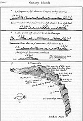
Map of the Canary Islands by William Dampier, 1699 (Project Gutenberg eText 15675).
From http://www.gutenberg.org/etext/15675/
Lizenz
| This image comes from the Project Gutenberg archives. This is an image that has come from a book or document for which the American copyright has expired and this image is in the public domain in the United States and possibly other countries.
This eBook is for the use of anyone anywhere at no cost and with almost no restrictions whatsoever. You may copy it, give it away or re-use it under the terms of the Project Gutenberg License included with this eBook or online at www.gutenberg.net. |
Dateiversionen
Klicke auf einen Zeitpunkt, um diese Version zu laden.
| Version vom | Vorschaubild | Maße | Benutzer | Kommentar | |
|---|---|---|---|---|---|
| aktuell | 16:30, 12. Jun. 2005 | | 500 × 732 (88 KB) | Tagishsimon | Canary Islands map by William Dampier 1699 - Project Gutenberg eText 15675 From http://www.gutenberg.org/etext/15675/ {{PD}} Category:Maps |
Dateiverwendung
Die folgenden 2 Seiten verwenden diese Datei:
Globale Dateiverwendung
Die nachfolgenden anderen Wikis verwenden diese Datei:
- Verwendung auf bn.wikipedia.org
- Verwendung auf bs.wikipedia.org
- Verwendung auf en.wikipedia.org
- Verwendung auf es.wikipedia.org
- Verwendung auf fr.wikipedia.org
- Verwendung auf ga.wikipedia.org
- Verwendung auf hr.wikipedia.org
- Verwendung auf it.wikipedia.org
- Verwendung auf sh.wikipedia.org
- Verwendung auf te.wikipedia.org
- Verwendung auf tt.wikipedia.org