Datei:CalabrianArc-GeotectonicSection.jpg

Originaldatei (5.974 × 1.629 Pixel, Dateigröße: 3,61 MB, MIME-Typ: image/jpeg)
![]()
Diese Datei und die Informationen unter dem roten Trennstrich werden aus dem zentralen Medienarchiv Wikimedia Commons eingebunden.
![]()
Beschreibung
| Beschreibung |
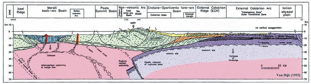
English: This picture (van Dijk, 1992, published also in van Dijk, 1994, and coloured versions are in van Dijk et al. 1998, 2000; reproduced by many other authors) shows a geological, geotectonic, structural section of the Central Mediterranean Subduction System, i.e. the Calabrian Arc.
All authors reproducing this figure in their work in original or modified form are kindly requested to correctly refer to the original source according to standard scientific ethics codes. It is an original compilation of the present knowledge regarding this complex system, and numerous references and discussions regarding previous knowledge can be found in the extensive bibliographies of van Dijk & Okkes (1990), van Dijk (1992) and van Dijk et al. (2000). The legend of the colours and the position of the section trace can be found on the map of the Central Mediterranean: http://commons.wikimedia.org/wiki/File:CentralMediterranean-GeotectonicMap.jpg It shows the overthrusting of the Calabrian Block also called "Calabrian Element", representing the southern Apennines and the Sicilian Maghrebides, of the promontory of the African Plate, the Ionian Sea. Furthermore the Tyrrhenian back-arc basin is shown with its recent volcanic arcs and tectonic stretching. It is underlined here that the internal structure of this Calabrian Block is only generally indicated in this figure; it is composed of a complex nappes pile dissected and deformed by transpressional fault zones, all generated during Late Eocene up to mid Pleistocene deformation phases. More details of this complex internal structure are depicted in the copyright protected figures of Van Dijk et al. (2000), which hopefully will soon become available in Wikipedia. It can be appreciated that the Calabrian Block is moving towards the southeast along a detachment plane situated at a depth of around 15 to 25 km which dips to the southeast, and therefore suggests an important component of gravitational forces guiding the sliding of this lithosphere element, as underlined by many researchers in the past, and more recently revisited in the scientific literature. How these gravitational forces may interact and alternate with interplate and intraplate stress components related to the regional plate movements in the central Mediterranean is extensively discussed in van Dijk and Okkes (1991) and later works. Domains that can be recognised include the Issel Ridge, The Marsili Basin, the Paola Basin, the Crotone Basin, also called Spartivento Basin, the external Calabrian Arc and the Ionian Abyssal Plain. The rupture of the subducted slab below the arc and its consequences in terms of isostatic restablisation, astenospheric wedging and other, can be appreciated. These are all extensively discussed in van Dijk and Okkes (1990) and van Dijk and Scheepers (1995). Another important phenomenon that is underlined in the figure is the incipient, start of subduction, of the Tyrrhenian crust, with a vergence of contraction towards the inner margin of the Arc, first proposed by van Dijk & Okkes (1990, 1991) and recently recognized also in other Mediterranean margins such as western North Africa.
van Dijk, J.P., and Okkes, F.W.M. (1988); The analysis of shear zones in Calabria. implications for the geodynamics of the Central Mediterranean. La Ricerca Scient., Suppl., 68, 24-27. van Dijk, J.P., and Okkes, F.W.M. (1990); The analysis of shear zones in Calabria. implications for the geodynamics of the Central Mediterranean. Riv. Ital. Strat. Paleont., 96 (2-3), 241-270. van Dijk, J.P., and Okkes, F.W.M. (1991); Neogene tectonostratigraphy and kinematics of Calabrian Basins. implications for the geodynamics of the Central Mediterranean. Tectonophysics, 196, 23-60. van Dijk, J.P. (1992); Late Neogene fore-arc basin evolution in the Calabrian Arc (Central Mediterranean). Tectonic sequence stratigraphy and dynamic geohistory. With special reference to the geology of Central Calabria. Geologica Ultrajectina, 92, 288 pp. van Dijk, J.P., and Scheepers, P.J.J. (1995); Neogene rotations in the Calabrian Arc. Implications for a Pliocene-Recent geodynamic scenario for the Central Mediterranean. Earth Sci. Rev., 39, 207-246. van Dijk, J.P., Barberis, A., Cantarella, G., and Massa, E. (1998); Central Mediterranean Messinian basin evolution. Tectono-eustasy or eustato-tectonics? Annales Tectonicae, 12, n. 1-2, 7-27. van Dijk, J.P., Bello, M., Brancaleoni, G.P., Cantarella, G., Costa, V., Frixa, A., Golfetto, F., Merlini, S., Riva, M., Toricelli, S., Toscano, C., and Zerilli, A. (2000); A new structural model for the northern sector of the Calabrian Arc. Tectonophysics, 324, 267-320. van Dijk, J.P., Bello, M., Toscano, C., Bersani, A., and Nardon, S. (2000); Tectonic model and 3D fracture network analysis of Monte Alpi (Southern Apennines). Tectonophysics, 324, 203-237. |
| Datum | |
| Quelle | van Dijk, J.P. (1992); ; Late Neogene fore-arc basin evolution in the Calabrian Arc (Central Mediterranean). Tectonic sequence stratigraphy and dynamic geohistory. With special reference to the geology of Central Calabria. Geologica Ultrajectina, Vol. 92, pp. 57, Fig. 1b. |
| Urheber | Jpvandijk, J.P. van Dijk, Janpieter van Dijk, Johannes Petrus van Dijk |
| Genehmigung (Weiternutzung dieser Datei) |
This is my own file. I created it and it is published in my public domain Ph.D. Thesis. |
Lizenz

|
Es ist erlaubt, die Datei unter den Bedingungen der GNU-Lizenz für freie Dokumentation, Version 1.2 oder einer späteren Version, veröffentlicht von der Free Software Foundation, zu kopieren, zu verbreiten und/oder zu modifizieren; es gibt keine unveränderlichen Abschnitte, keinen vorderen und keinen hinteren Umschlagtext.
Der vollständige Text der Lizenz ist im Kapitel GNU-Lizenz für freie Dokumentation verfügbar. |
- Dieses Werk darf von dir
- verbreitet werden – vervielfältigt, verbreitet und öffentlich zugänglich gemacht werden
- neu zusammengestellt werden – abgewandelt und bearbeitet werden
- Zu den folgenden Bedingungen:
- Namensnennung – Du musst angemessene Urheber- und Rechteangaben machen, einen Link zur Lizenz beifügen und angeben, ob Änderungen vorgenommen wurden. Diese Angaben dürfen in jeder angemessenen Art und Weise gemacht werden, allerdings nicht so, dass der Eindruck entsteht, der Lizenzgeber unterstütze gerade dich oder deine Nutzung besonders.
- Weitergabe unter gleichen Bedingungen – Wenn du das Material wiedermischst, transformierst oder darauf aufbaust, musst du deine Beiträge unter der gleichen oder einer kompatiblen Lizenz wie das Original verbreiten.
Dateiversionen
Klicke auf einen Zeitpunkt, um diese Version zu laden.
| Version vom | Vorschaubild | Maße | Benutzer | Kommentar | |
|---|---|---|---|---|---|
| aktuell | 11:08, 14. Jun. 2010 | 5.974 × 1.629 (3,61 MB) | Jpvandijk | Indications of geographic orientation of the section. Some cleaning. | |
| 13:30, 13. Jun. 2010 | 5.974 × 1.629 (3,6 MB) | Jpvandijk | The correct color is inserted for the external tectonic units and some Neogene deposits, in order to comply better to the linked Geotectonic Map. | ||
| 13:36, 12. Jun. 2010 | 5.974 × 1.629 (3,6 MB) | Jpvandijk | File name and some resolution enhancement. | ||
| 14:04, 24. Mai 2010 | 5.974 × 1.629 (3,6 MB) | Jpvandijk | The rectangular box indicating the "field study area" has been removed, as was done by other authors that reproduced the picture, to make it still more general in its usage in scientific publications. | ||
| 13:59, 24. Mai 2010 | 5.974 × 1.629 (3,6 MB) | Jpvandijk | The rectangular box indicating the area "field study area" has been removed, as was done by other authors that reproduced the picture, to make it still more general in its usage in scientific publications. | ||
| 14:51, 22. Mai 2010 | 5.974 × 1.629 (3,6 MB) | Jpvandijk | The white surrounding areas of the picture have been removed. | ||
| 14:32, 22. Mai 2010 |  | 9.925 × 7.017 (2,56 MB) | Jpvandijk | {{Information |Description={{en|1=This picture (van Dijk, 1992, published also in van Dijk, 1994, and coloured versions are in van Dijk et al. 1998, 2000; reproduced by many other authors) shows a geological, geotectonic, structural section of the Central |
Dateiverwendung
Die folgende Seite verwendet diese Datei:
Globale Dateiverwendung
Die nachfolgenden anderen Wikis verwenden diese Datei:
- Verwendung auf en.wikipedia.org
- Verwendung auf it.wikipedia.org
- Verwendung auf pcd.wikipedia.org
- Verwendung auf ru.wikipedia.org
- Verwendung auf zh.wikipedia.org