Datei:American attack on Quebec.svg

Originaldatei (SVG-Datei, Basisgröße: 883 × 1.077 Pixel, Dateigröße: 752 KB)
![]()
Diese Datei und die Informationen unter dem roten Trennstrich werden aus dem zentralen Medienarchiv Wikimedia Commons eingebunden.
![]()
Beschreibung
| Beschreibung |
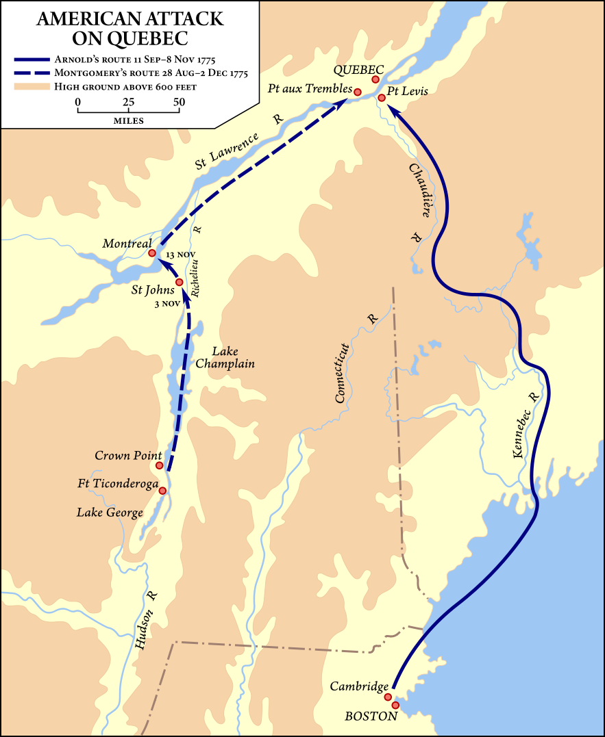
Map showing the routes taken by the Benedict Arnold and Richard Montgomery expeditions into Quebec as part of the American Invasion of Canada (1775). |
| Datum | Vectorized September 19–20, 2008 |
| Quelle | Vector version of Image:American quebec 1775.jpg, from American Military History, United States Army Center of Military History, 1989, courtesy of the University of Texas Libraries, The University of Texas at Austin. |
| Urheber | United States Army Center of Military History, vector version by Fvasconcellos (Diskussion · Beiträge) |
| Genehmigung (Weiternutzung dieser Datei) |
This image is derived from a work of the U.S. government and, as such, is in the public domain. |
| Andere Versionen | Image:American quebec 1775.jpg |
Lizenz
| This image is in the public domain because it contains materials that originally came from the United States Army Center of Military History, subject to the following qualification.
Note: The images of all badges, insignia, decorations and medals on the "CMH Online" web site are produced by the United States Army Institute of Heraldry and protected by Title 18, United States Code, Section 704 and the Code of Federal Regulations (32 CFR, Part 507). Permission to use these images for commercial purposes must be obtained from The Institute of Heraldry prior to their use. |

|
Dateiversionen
Klicke auf einen Zeitpunkt, um diese Version zu laden.
| Version vom | Vorschaubild | Maße | Benutzer | Kommentar | |
|---|---|---|---|---|---|
| aktuell | 03:54, 21. Sep. 2008 | | 883 × 1.077 (752 KB) | Fvasconcellos | ==Summary== {{validSVG}} {{Information |Description=Map showing the routes taken by the {{w|Benedict Arnold}} and {{w|Richard Montgomery}} expeditions into Quebec as part of the American {{w|Invasion of Canada (1775)}}.<br/> Vector version of [[:Image:Ame |
Dateiverwendung
Die folgende Seite verwendet diese Datei:
Globale Dateiverwendung
Die nachfolgenden anderen Wikis verwenden diese Datei:
- Verwendung auf ca.wikipedia.org
- Verwendung auf da.wikipedia.org
- Verwendung auf en.wikipedia.org
- Verwendung auf es.wikipedia.org
- Verwendung auf fr.wikipedia.org
- Verwendung auf he.wikipedia.org
- Verwendung auf id.wikipedia.org
- Verwendung auf it.wikipedia.org
- Verwendung auf ja.wikipedia.org
- Verwendung auf ko.wikipedia.org
- Verwendung auf ms.wikipedia.org
- Verwendung auf pt.wikipedia.org
- Verwendung auf ro.wikipedia.org
- Verwendung auf ru.wikipedia.org
- Verwendung auf sh.wikipedia.org
- Verwendung auf uk.wikipedia.org
- Verwendung auf www.wikidata.org
- Verwendung auf zh.wikipedia.org